A brief History of Wembdon
The name Wembdon is derived from “The Hill of the Hunter”. The ancient parish is in Somerset, in the South West of England, one mile to the north west of Bridgwater and was on the “Pilgrims Route”, the main road from the town to Minehead and beyond. The village extends across the Somerset wetlands to the Wembdon Ridge from which there are spectacular views across the moors to the Bristol Channel and westwards to the Quantock Hills.
Drainage of the lowland areas was commenced in Roman times to create farmland, and the upper part of the village is famous for its quarrying. Evidence of Roman settlements has been found to the north of the village, in a number of locations across Perry Moor. The triangular area bounded by Wembdon Hill, Moore’s Lane and Hollow Lane may have been a Bronze Age defensive site. In 1984 an early medieval burial site (7th Century) was discovered during works on Wembdon Hill. Wembdon was listed in the Domesday Book of 1086 as having “5 villagers and 6 smallholders with four ploughs”.
The village was small (population 244 in the 1801 census) with much of the area laid to orchards until the early 19th Century when building of houses along Wembdon Rise started; followed in the early 20th Century by the homes along the top of the hill (‘Mount Radford’). In 1922 the village was by-passed with the construction of the Quantock Road and in more recent years the building of the Bridgwater Northern Distributor Road has cut through the parish, bringing with it hundreds of new homes. The current population of the parish is estimated at 3500 inhabitants. Further housing estates, totalling around 1200 homes, are planned along the Quantock Road, some of which will fall within Wembdon Parish.
The area is known for the red sandstone which was quarried from the 12th Century or earlier and was quarried for over seven centuries. Wembdon stone was used for the building of Bridgwater Castle from 1200-1215 and it can be seen throughout Bridgwater including the tower of St Mary’s church.
The largest and last surviving quarry lies behind the 14th Century Holy Well House, which was originally built as a monastery. It is no longer used and is a haven for wildlife. Nearby is the Holy Well, earlier known as St John’s Well, whose waters were famed for their restorative properties, particularly for problems with eyesight. The Well still exists in the garden of a private dwelling.
Just a few hundred yards further up the hill lies Cokerhurst Farm which is a classic example of a Somerset Longhouse, built around the 15th Century and retaining many original features. Sandford Manor (built c.1500) is located at the junction with Sandford Hill and the A39. As the name suggests it was the location of a sand quarry, the sand being the same colour as Wembdon stone. The remains of a medieval settlement from about the same period were found just across the road.
The road through the village was turnpiked in 1730. The first toll house after leaving Bridgwater was at the lower end of the approach to Wembdon Rise and was known locally as ‘White Gate’. The upper end of the toll road was marked by a toll house at the junction with Skimmerton Lane. Both are now private dwellings, the lower toll house serving as a police station for some time.
Farming was the largest occupation in Wembdon for many years and there was also a smithy, a horse drawn taxi service, a dairy, a motor garage, an undertaker, and a brewery. In 1881 there was George’s Coffee Tavern, situated on the site of the old post office. The village shop, a few houses down the hill, now contains the Post Office.
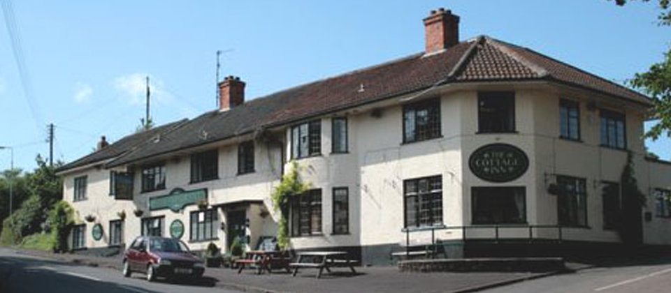
As befits such an important route, there were a number of ‘watering holes’ in the village, dispensing hospitality to travellers. At least four public houses are on record. The Cottage Inn may be the oldest, traced to 1743. In 1860 it was also a grocers and is the only public house still in business in the village today. The Rest and be Thankful was trading in 1856 but the exact location is unknown and records show that The Templer’s Inn was trading in 1861, later becoming the Rock House Inn, now a private dwelling. Little is known about The Wembdon Inn which adjoined the smithy and was replaced by Hoxton House in 1889.
By 1870 Wembdon was a small but thriving village. Between 1801 and 1871 the population had more than quadrupled and it seemed to the vicar, Reverend Arthur Newman, that a new Church of England school was both desirable and necessary. The Reverend Newman therefore decided to raise a subscription for a new school and set the ball rolling by making a large contribution himself. When about £900 had been raised, an architect was appointed and a tender accepted from builders for the construction of the school on a site opposite the Church. Wembdon School, later known as St George’s Primary School, occupied the building until 1992, when it moved to new buildings in Brantwood Road, and is now Wembdon St George’s Church School. The Victorian building subsequently became the Parish Centre, and was also used by the Sunshiners Pre-school until they moved to the new Village Hall in 2017.
A fuller history of Wembdon can be found in British History Online.